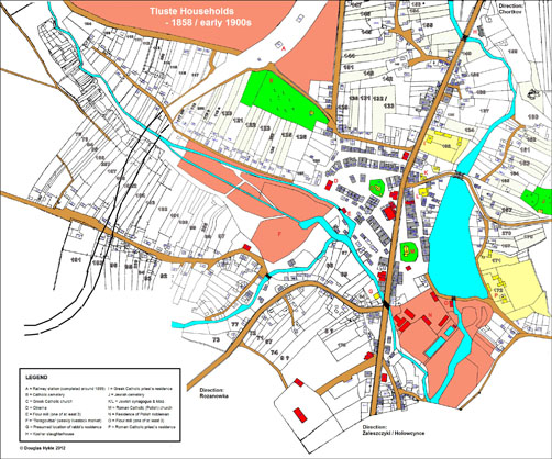
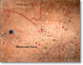
Tluste Households - 1858
/ early 1900s
The following is a preliminary compilation and analysis
of plots and building locations in Tluste. Among other things,
the presentation reveals the high concentration of Jewish
households in the centre of town and their limited occurrence
elsewhere; the affluence of the local Polish nobleman, at
least in terms of his extensive landholdings; the relatively
generous treatment accorded the Roman Catholic and Greek Catholic
clergy, and the rather extensive system of agricultural plots
owned primarily by Ukrainians and Poles. The information has
been used in the first instance to identify the precise locations
of some 135 Jewish households in 1879, to document the names
of heads of households at that time, and to point out a number
of key features of the town.
Click on the map below to view an enlarged, detailed map of
plots and building locations in Tluste, which has been carefully
constructed using archival information available from 1858
to the early 1900s. As will be explained below, it is based
on a composite of two maps with very similar characteristics,
separated in time by about a half century.
| |
 |
|
| |
Composite map of plots and building locations in
Tluste - 1858 / early 1900s
Click to view an enlarged map in new window and
click again to zoom
|
|
Background
The underlying (base) map is actually a refined version of
a very detailed, precise map of plots and building locations
in Tluste, estimated to have been produced between about 1900
and 1912, on file at the Central State Historical Archives
of Ukraine in Lviv (ref. Fond 186, Opus 14, Sprava 89).
| |
|
|
The presumed time frame has
been determined by certain features included in the map,
namely the right-of-way for the railway, which was completed
around 1899, and the outline of the old Greek Catholic
church in the centre of town, which was demolished around
1912 to make way for construction of a new edifice.
While the original map (shown here) gives no information
whatsoever about house numbers, its precise illustration
of individual buildings and associated plots makes it
extremely valuable. |
|
|
| |
|
|
The early 20th century base map, described above, excludes
most of the western extremity of Tluste, more or less where
the railway bisects the town. To compensate for this important
omission, a portion of a cadastral map dating from 1858 has
been appended to the base map, after some processing to remove
extraneous detail. The extra portion makes up about 30 percent
of the entire composite map, starting from the left hand side.
That this seamless merging of two maps separated by 50 years
in time is possible attests to the fact that for about two
centuries the configuration of plots – and, to a lesser
extent, the locations of individual buildings – within
Tluste has remained fairly constant. While the extent of correspondence
has diminished over time, a very high correlation is still
evident when one compares the mid-19th century map with aerial
photographs of the town taken in the 1940s. Even comparing
the earliest known map of Tluste, a partial cadastral map
dating from about 1828, to a modern map of the town produced
after 2000, one can still discern similar patterns and shapes
of plots.
To summarise, a map comprising two merged sections (one part
from the early 1900s, the other from 1858) has been used
as a foundation on which to add other features which are described
below. 
Guide to the map contents
The most important annotation made to the composite base
map is the indication of building and land parcel
numbers, which have been derived from two cadastral
maps on file at the State Archives of Ternopil Oblast. The
first of these is a beautiful, colour map produced in 1858
during the period of the Austro-Hungarian Empire; the second
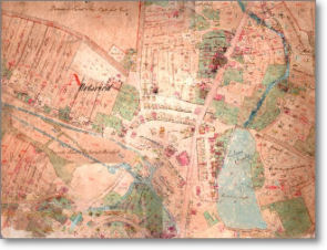
is a much plainer, updated map which is thought to have been
produced in the late 1890s, since it shows a faint outline
of where the new railway line would be situated.
| |
 |
|
 |
|
|
|
Cadastral Map of Tluste
- 1858 |
|
Cadastral Map of Tluste
- ca. 1899 |
|
|
Like the base map from the early 20th century, both of the
earlier 19th century maps show individual buildings and plots;
and, most importantly, they also reveal details of the building
and plot numbers. Thanks to consistency in the layout of plots
and buildings from one period to another, it was possible
to transpose the numbers from the earlier maps (i.e. 1858
and ca. 1899) onto the early 20th century base map. These
numbers were often difficult to read, however, and a painstaking
process of comparison between all three maps was needed to
arrive at result that is considered to be highly accurate
and about 90 percent complete.
With reference to the large composite map shown above:
Water bodies, shown in light blue,
include the unmistakable large reservoir to east of the main
north-south thoroughfare that divides Tluste, the narrow Dupa
“river” (more like a stream) flowing into and
out of the reservoir; as well as various smaller channels
flowing in different directions.
Roads are shaded in brown,
and the right-of-way for the railway, completed
around 1899, is clearly shown as a wide strip in the upper
left hand portion of the early 20th century base map. It is
interrupted where it meets the adjoining 1858 map, where it
is depicted instead by two dashed lines.
Yellow shading is used to indicate buildings
associated with each of the three religious faiths
represented in Tluste: Greek Catholic, Roman Catholic, and
Jewish. That is to say, churches, synagogues, and residences
and associated buildings of their respective spiritual leaders.
Catholic and Jewish cemeteries are highlighted in bright green.
Red is used to indicate the residence and
other buildings associated with the Polish nobleman
of Tluste who, in 1858, was Fürst (Prince) Kalikst Poninski.
Some, but not all of his land holdings, are also denoted with
lighter red shading.
Grey shading is used to indicate households
which, according to the names appearing in a separate list
of heads of households dating from 1879 were in all probability
Jewish. The relevant reference is on file
at the Central State Historical Archives of Ukraine in Lviv
(ref. Fond 186, Opus 1, Sprava 8736). Shading to differentiate
between Polish and Ukrainian households has not yet been attempted.
While it is virtually certain that the houses shaded in grey
were Jewish households, the same cannot be said for the converse
(ie. that houses without any shading were non-Jewish). Most
of this uncertainty will be removed once the Ukrainian and
Polish households have been thoroughly documented.
Individual building numbers, shown in small
blue font, are usually placed within the borders
of the building with which they are associated. Occasionally,
a question mark “?” is used to denote uncertainty
about the number or location; square brackets are used to
indicate a building that appeared in an earlier map but was
no longer present in the early 1900s.
Plot numbers, shown in large grey
outline font, are shown only for large parcels of
land, which are sometimes subdivided into smaller sections.
Very faint shading has been added to help distinguish a parcel
comprising multiple sections from an adjacent parcel. Note
that while plot numbers are usually sequential, occasionally
the sequence is interrupted. Plot numbers also exist for much
smaller pieces of land, such as gardens or land completely
occupied by a dwelling, but these have not been depicted to
avoid cluttering the map.
Short connecting lines (squiggles) on the map are presumed
to indicate buildings and pieces of land that are associated
(i.e. that belong to the same household).
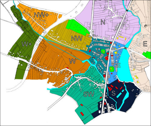
Key features on the map
For purposes of analysing the contents of the composite map,
and the 1879 heads of household list, it may be helpful to
divide the main map into smaller areas that have some geographic
affinity, as shown in the following multi-coloured representation.
The subdivisions are somewhat arbitrary but they could be
indicative, to some extent, of how households in different
parts of the town interacted with one another – or did
not interact very much – on account of physical or man-made
barriers, or cultural/religious differences.
The ten zones shown on the map may be described as follows:
| C |
Teal Blue
|
Town centre, to the west of the main north-south
thoroughfare, with the Greek Catholic (Ukrainian) church
at its core |
| CE |
Blue |
Town centre, to the east of the main thoroughfare, with
two significant loci: the Roman Catholic (Polish) church
and the main Jewish synagogue |
| E |
Pink |
Area to the east of the large reservoir and the northern
part of the Dupa river |
| N |
Purple |
Area to the north of the town centre, bordering the
main road heading in the direction of Chortkov |
| S |
Navy Blue |
Area to the south of the reservoir, and associated with
the main road that begins to lead southward, in the direction
of Zaleszczyki |
| SW |
Jade |
Area to the southwest of the town centre, bounding the
main arterial road leading to Rozanowka |
| W |
Copper |
Area to the west of the town centre, bounded by streams
to the north and east, and intersected by a road leading
westward towards agricultural plots |
| W+ |
Green |
Continuation of the W area, separated from the rest
of town by the railway line |
| NW |
Brass |
Area to the northwest of the town centre, bounded by
the Catholic cemetery to the north and a stream to the
south |
| NW+ |
Orange |
Continuation of the NW area, separated from the rest
of town by the railway line. |
Analysis of the household information
We return now to the base map, which highlights a number
of buildings and areas known to exist in 1858 – the
one exception being railway station completed around 1899,
which has also been marked. The legend at the bottom left
hand side of the map lists these features, some of which are
described in more detail in the text that follows (or elsewhere
on this website).
An analysis of the 1879 archival records reveals approximately
275 unique households in Tluste, which may be interpreted
as discrete family units. (About 30 individuals who were apparently
associated with multiple properties have not been counted
more than once.) An examination of first and last names among
these heads of household indicates, with a high degree of
certainty, that about 50 percent of them (approximately 135)
were Jewish.
This seems to be at odds with other demographic
data indicating that, from 1880 to 1900, Jews represented about
two-thirds of the population of Tluste. In 1880, for example,
out of a total population of 3285 individuals, 2225 were recorded as Jewish.
No explanation is immediately available to account for the apparent discrepancy in the proportions, which might be attributed to larger Jewish
family sizes compared to gentile households (thus making a
larger contribution to the total population for the same number
of households); or additional Jewish residents who were not
accounted for in the 1879 list. For the time being, if the census data are accurate, the only conclusion that one can draw is that Jewish and non-Jewish households averaged about 16.5 and 7.5 individuals per household, suggesting a marked difference in family size and structure.
In any case, one of the most striking features that one observes
from the composite map is that, of the 135 Jewish households
in Tluste, approximately 70 percent were concentrated in the
centre of town, as evidenced by the large number of gray-shaded
buildings (i.e. houses and/or shops) in the C and CE zones
described above. A smattering of Jews did live in other areas,
but they were very much an exception to the rule. About 40
households are found in a half-dozen other areas; but almost
no Jews lived in the west, northwest or east of town. Similarly,
while a small number of gentiles (Poles and Ukrainians) did
live and/or own shops amongst Jewish households in the centre
of town, they were a very small minority.
The 1879 household list provides information on the sizes
of many dwellings, with fairly comprehensive coverage for
the town centre. Pending further investigation, the values
given are assumed to be in square meters, however it is not
clear whether this represents the full size of the house/shop
or only its “footprint” on the ground. It is presumed
that a building might have had a second story or an attic
that was not differentiated in the figures. The building sizes
generally ranged along a uniform continuum from about 20 to
120 square meters, with some small and large outliers beyond
each end of this scale. The average house/shop size would
have been about 50 square meters. The 1879 list also confirms
that some Jews – around 25 percent – did own land
apart from that on which their house/shop stood, but the plots
were relatively small compared to those owned by Ukrainians
and Poles.
A second prominent feature that stands out from the map is
the number of buildings and land possessed by the Polish nobleman
Poninski, indicated with two shades of red. They include a
large estate in the southern part of town (which would later
be transformed into a work camp, when Tluste came under German
occupation), several large buildings in the central market
area, the cinema and at least two flour mills.
The Greek Catholic priest lived on a fairly large property
on the main road, just north of the reservoir, which included
a large house and barns/sheds for keeping animals and storing
feed. His Roman Catholic counterpart lived on an even larger
estate, with numerous buildings, located just beyond the southeast
corner of the reservoir. The actual property can be seen in
a rare sketch estimated to date from the 1880s. The main residence
still stands on the exact same location today, albeit after
some transformation.
Tluste’s orthodox rabbi is thought to have occupied
a large two story building (still standing today) close to
the “bridge” that joins the southern part of town
with the centre. While it is marked as such on the map, definitive
information on its location is missing from the 1879 list
of households and associated cadastral map.
It is worth mentioning that several dozen households, perhaps
50 or more, beyond the southern limit of Tluste proper are
not shown on the map under review and are not included in
any of the statistics presented above. Technically these households
– located on the main road leading to Zaleszczyki and
the arterial road leading to the nearby village of Holowcynce
– were part of the neighbouring community of Tluste
Wies. For all intents and purposes, however, these households
were no different than any others in Tluste proper and were
not geographically separated in any way. Tluste Wies is nonetheless
relevant to a discussion of life in Tluste, as many of its
residents are thought to have been Jewish and would have added
to the totals mentioned above.
Finally, the area designated as SW (southwest) is not as
well documented as the others, mainly because the building
and plot numbers on copies of both the 1858 and 1899 maps
are almost illegible. Review of the original maps might help
to discern some of these households, which are thought to
be a mixture of Poles, Ukrainians and some Jews.
Alphabetical listing of Jewish households - 1879
Using the 1879 list of households, including building and
plot numbers, one can identify all of the Jewish households
in Tluste about 130 years ago. It may never been known whether
there were other Jewish families living in Tluste at the time
who did not appear in the list of households, for whatever
reason, but given that most of the individual buildings in
the town have been identified, their number is likely to be
small.
What can this information tell us (or not tell us)? It is
important to note that the 1879 list, which appears to be
the latest extant official record of individual Jewish households
in Tluste, is not a census. It only provides information on
the head of the household, who was usually – but not
always – male. No details of other family members occupying
the same dwelling are given. In the absence of information
passed down from generation to generation, perhaps the most
useful contribution of the 1879 list, is that it may reveal
previously unknown names of grandfathers or great-grandfathers.
In the interest of facilitating family connections to the
past, a complete alphabetical listing of the heads of Jewish
households in Tluste in 1879 follows. If you would like to
know exactly where a particular household was located, please
feel free to contact me using the Feedback
page.
NB: names are written as they appear in the 1879 household
list, including small variations in spelling which may differ
from current usage.
| ABOSZ, Szendel |
HORNIG, Leizor |
RIENISZ, Leib Szaja |
| ASZKELES, Srul |
HORNING, Mendel |
RIENISZ, Yuda |
| ASZKINAS, Szymon |
HOROWITZ, Aron |
RIZEL, Mortko |
| AUSFELD, Elie |
KALENBERG, Abraham |
ROZENBAUM, Chaim |
| AUSLANDER, Chaim |
KIMELMAN, Feiwel |
SCHACHTNER, Szloma |
| BADLER, Antszel |
KIMELMAN, Hersz Mortko |
SCHACHNER, Mortko |
| BADLER, Eisig |
KLEIN, Szymon |
SCHECHNER, Mojsie |
| BADLER, Feige |
KLUGER, Szloma |
SCHECHNER, Szloma |
| BADLER, Jankiel |
KLÜGER, Leib |
SCHECHNER, Szmul |
| BADLER, Reifla |
KRAMER, Hersch |
SCHECHNER, Yosel |
| BADLER, Reise |
KUTNER, Mojzesz? |
SECHNER, Yankel |
| BRAUN, Emanuel |
LANG, Hiller |
SETTER, Kalman |
| BRUCKNER, Abraham |
LANG, Leib |
SIGAL, Abraham |
| BUCHHALTER, Leib Szmil |
LANG, Selig |
SILBER, Szloma |
| BUCHHALTER, Nuta? |
LANG, Szlomo |
SPITZER, Kopel Leib |
| DANTER, Mortko |
LANGHOLZ, Chaim |
SPITZER, Motio |
| EISIG, Chaskel |
LANGHOLZ, Gabriel |
STERNLEIB, Icyk |
| ETLINGER, Leib Mojzen |
LANGHOLZ, Szapse |
STERNLEIB, Michal |
| FASSLER, Izak |
LIBLSIG?, Josel |
STERNLEIB, Mortko |
| FIDER, Srul / Szmil |
LUBLIN, Chaim |
STOLAR, Kalman |
| FIDERER, Berl |
MAIMAN, Getzel |
STUP, Aaron |
| FIDERER, Handel |
MAJMAN, Lejsor |
STUP, Hibel |
| FIDERER, Szmil |
MAIMAN, Menie |
STUP, Model? |
| FIDERER, Yosel Chaim |
MAJMAN, Mortka |
STUP, Srul |
| GABA, Abraham |
MAJMANN, Götzel |
SZENKELBACH, Mendel |
| GABA, Majer |
MAJMANN, Izak Abraham |
SZMELCER, Szmaja |
| GERTNER, Aron |
MAJMANN, Mortko |
SZTENZLER, Szaja Berl |
| GERTNER, Manie |
MELCER, Kolman Motio |
SZWARTZ, Hersch |
| GERTNER, Szymon |
MELTZER, Motio |
TAIWER, Hersch |
| GRABSTEIN, Major Icyk |
METZGER, Uszer |
TAIWER, Icyk |
| GRIL, Mendel |
MEZGER, Izak |
TAIWER, Motel |
| GRINSPAUN, Szaja |
MORGENSTERN, Herzel |
TAIWER, Mozes |
| GRÜNSPAN, Mojzesz |
MORGENSTERN, Leib |
TAIWER, Simke |
| HALPERN, Dwora |
NADLER, Ello |
TEPER, Chaim Leib |
| HARTMAN, Szmul |
NAGLER, Chaim |
TEPPER, Antszel |
| HARTMANN, Basia |
NEJFELD, Majer |
TOIVER?, Chaim |
| HELLER, Etie |
NEUMANN, Bycia / Benjamin |
WEINBERGER, Jakób |
| HENTSCHEL, Abraham |
OELBERGER, Litman |
WEINSTOCK, Henzel |
| HESSING, Alter |
OSIAS, Elenbogen |
WEISCHEL, Mojzesc |
| HESSING, Ello |
PERLMUTTER, Szmil |
WEKSER, Mendel |
| HESSING, Leib |
PFEFER, Hersch |
WOLF, Abraham |
| HESSING, Simon |
PLACKER, Salamon |
YUDA, Ello |
| HESSING, Yosel |
POPIEL, Simion |
|
| HORING?, Antszel |
PREISMAN, Hersch |
|
| HORNIG, Jacób Wolf |
RAJNISZ?, Hersch |
|
Obviously, the information from 1879 cannot be used to determine
who was living in Tluste at the onset of World War II, some
60 years (or about three generations) later. However, other
independent sources of contemporary information can, and sometimes
do, reveal links in individual household/plot occupation between
1879 and 1939. For example, the 1879 list indicates that Chaim
Langholz occupied building number 261, adjacent to the residence
of the Greek Catholic priest; and it is known from independent
interviews with Tluste survivors that a Langholz family lived
in a house on the very same plot during the war.
It is probably more often the case that Jewish families who
lived in Tluste in 1879 and remained there for several generations,
moved into other dwellings as their personal situations changed.
So, for example, one can find a family name associated with
a particular house in 1879 represented at another location
in 1939, with a fairly high probability that there is some
connection between them. Indeed, dozens of surnames appearing
in the 1879 list can be identified among the Jewish victims
recorded in the Sefer Tluste memorial volume published in
1961, suggesting that these families had lived in the town
for several generations.
The Central State Historical Archives of Ukraine has an even
older record of Tluste households dating from 1828 (ref. Fond
186, Opus 1, Sprava 8737). A cursory review of that list reveals
several Jewish surnames which were associated with Tluste,
virtually without interruption, for over one hundred years
until the onset of World War II. They include names such as
Fiderer, Gertner, Hertman, Langholz, Nadler, Reinisz, and
Stupp.
This preliminary research, focussing primarily on Jewish
households in Tluste, has only scratched the surface of what
can be done with this and other archival material; and it
will be continued in more breadth and depth as time permits.
|


))