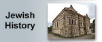
| Former Synagogue of
Tluste
 |
|
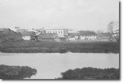
A rare photograph, taken in 1931, shows
the synagogue of Tluste in its former glory. The greyish-white
stone building, with a light coloured roof, is seen from
across the pond. Across the road from the synagogue, to
the north, stood a small prayer house and/or ‘house
of study’ – perhaps more than one building.
Pawlyk (pers. comm.) recalls, as a young boy in the mid-1930s,
this being a wooden structure. |
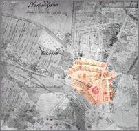
| An Austrian-drawn map of Tluste dating from
1858 confirms the synagogue's presence. It was located
near the junction of the main north-south road to Chortkiv
and the road leading eastward to Lisivtsi. It was situated
on the edge of what was then a mostly unoccupied green
area, not far from the northwestern extremity of the large
reservoir. Nearby, on the main road, was a long row of
shops, many of which would probably have been owned by
the town’s Jewish population. Although not marked
explicitly as a synagogue, the same building also appears
on an map of Tluste from 1899. |
|
 |
If the earlier map has been drawn to scale – and from
other comparisons this appears to be the case – the
synagogue would have been approximately as large as the former
fort (today, a recreation hall) located further to the west.
The latter structure is 12 m wide by 24 m long.
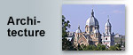
The synagogue, the Greek
Catholic church (more or less opposite, on the other side
of the main road) and the Roman
Catholic church (further down the road, in the direction
of Zalishchyky) formed a triangle. The distance between them
was only about 100-150 meters.
 |
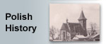
|
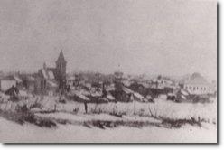
A grainy panoramic photo, taken from
a similar vantage point in 1939, captures the Roman
Catholic church to the left, the dome of the Greek-Catholic
cathedral in the middle (barely visible), and the monolithic
structure to the right. In former times, when all of
these buildings were in their prime, it must have been
an impressive sight to see all of the religious faiths
in Tluste represented in such a small area.
|
On file at the Tovste museum is a handwritten note, of unknown
origin, describing the interior of the synagogue in some detail.
Presumably, it is a first hand recollection of someone in
the congregation:
“The great Synagogue of Tolstoje was built in the
beginning of the 20th century. It was on the way to Lisowitz,
near the praying house (clois) of Hasidei czortkow and opposite
the Beis-Midrasz (House of Study). There was a praying room
too, of Hasidei Wiznic.
The synagogue was built of stone. Steps and an entrance
gate led to the hall. A small corridor on the right led
to a small praying room of artisans; there they were praying
in the mornings. In the afternoon there was a “Heder”,
where children were learning.
On the left was the entrance to a large hall, in the middle
of which was a pulpit, decorated with lamps, and on the
eastern side was the Holy Ark, covered with embroidered
curtain. Wide steps led to the second floor, where women
were praying.
The walls of the Synagogue were decorated with paintings.
The scenes were from the Bible, emblems of the tribes of
Israel, on light blue background. Around were windows with
painted vitrages (stain-glass).”
The stated origins of the synagogue raise an interesting
discrepancy. It is written that at the turn of the twentieth
century, it was decided to convert or reconstruct the remains
of what had bee, one of Tluste’s four forts for use
as the town’s principal synagogue. However, the fact
that the 1858 and 1899 maps already show the presence of a
large synagogue appears to be at odds with that assertion.
Perhaps the old fort was already in use as a synagogue in
1858, but was subsequently renovated around the turn of the
century?
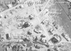
| Sadly, the Nazis destroyed the synagogue
around 1942, some time during their occupation of Tluste.
An aerial photograph taken during a German reconnaissance
flight in May 1944 shows what appear to be the remains
of a wall and one corner of the building. Today, there
are no traces left of it, nor of the Jewish community
that once thrived in Tluste. |
|
 |
If you have any comments or additional information on the
former synagogue of Tluste, including photographs or other
descriptions, please use the Feedback
page to share them. 
|


))