|
Where
exactly is Okup (Okopy)?
Searches on the internet for maps that might show Okup, and examination
of modern and historical maps of Poland and present-day Ukraine, are
not very revealing. The village is simply too small. However a source
described in the endnotes (15),
yields positive results.
 |
|
|
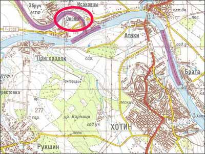
On a 1:100,000 scale map (which until recent years was not
easy to come by) Okopy -- 5 km northwest of Khotyn -- is barely
visible and is easily missed.
This may explain why most authors simply give the name of
the village without any specific geographic reference.
|
| |
|
|
|
In fact, there are no fewer than five villages in Ukraine with
the name Okop or Okopy. Three of them are located too far north
or east to be likely candidates. One is situated about 80 km due
south of Rivne and roughly 100 km east of Brody – presumably
the one cited in JewishGen’ ShtetLinks – though it is
not very “near Brody”, as claimed there. The other is
the correct location, described by Heppenheimer.
Zakharii, in his historical guide to Galicia (16),
mentions that, from 1692, Okopy boasted a castle of the Holy Trinity,
built on the rocky isthmus between the Zbruch and Dniester rivers.
Overlooking what was once Turkish -- and then Russian -- land, it
was strategically important at the end of the seventeenth century
(i.e. at around the time Rav Israel was born). |